By Shawn Bagley
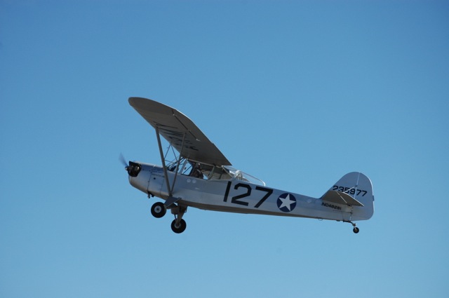
Every pilot has a story about an exciting cross country flight, or rather, stories about mishaps that made the cross country more than just boring hours of straight and level flight. One of my most exciting cross country flights was when I flew from Rexburg, Idaho to Nampa, Idaho in a Taylorcraft L-2A Grasshopper.
The L-2 is the odd looking half-brother of the venerable J-3 Cub. By 1941 the United States Army Air Force started ordering the L-2 for use as spotters on the front lines.
I heard that the Legacy Flight Museum needed to return the L-2 to its owner after several years on loan to the museum. I made all the subtle hints of a fire engine at a stop light, that I would be willing to take the time to transport the aircraft to its new home. Surprisingly, I won the bid, which I soon found out was due to the concern of flying across the southern half of Idaho in a plane with less horse power than a space heater.
To be fair, this little L-2 had been souped up. Instead of the original 65 horse engine, this plane had been upgraded with 85 purring ponies under its open cowling. I began calculating the best route for my flight. It was 206 nautical miles, if I made a B-line for the Nampa airport. This sounded very appealing, but if I flew straight through I would be crossing over 100 miles of lava bed. This includes a piece of ground known as Craters of the Moon. A place with terrain so terrible, that NASA tested their Moon Rovers there before sending them to space. Rather than flying my little plane over NASA’s version of the Rubicon trail, I opted to stay over highway and potato field. This would increase my mileage to over 260 nautical miles, but that was a risk I was willing to take.
Even with a blazing 85 horsepower, I was not going to be seeing anything close to 100 miles per hour. I recalled, from previous flights, that the L-2 would indicate somewhere around 85 miles per hour, but that didn’t take into account that I would still be facing some headwind along the way. Hoping to maintain at least 70 miles per hour, I pulled out a paper sectional and planned fuel stops every 75 to 90 miles following the highway. I calculated it would take me about four hours of flying, plus the time it takes to stop and fuel up every hour to hour and a half. Being a diligent flight instructor, I called for a weather briefing, like I teach my students to do.
“What is the forecast between Rexburg, Idaho, and Nampa, Idaho for the next six hours?”
“Six hours? Are you driving?” said the Flight Briefer.
“I might as well be.” I grimly replied.
When I was young, long before I could even think of flying a plane by myself, my dad took me on a flight in an L-4 Grasshopper (a drafted J-3 Cub). We were going to fly to our house about 7 miles from the airport and land in the field. We got bored about three miles in and turned around and went back to the airport. We had left with full fuel and had to stop at a gas station to make the return trip. My first stop was Aberdeen. I thought there was a crop duster operation there that I would be able to buy fuel from. When I landed, there was no fuel pump. There was no fuel truck. There was not even anyone at the airport to ask.
So, getting low on fuel, I turned around on the runway and took off in the direction of American Falls, a little over 9 miles away, flying over the American Falls Reservoir. I tried to balance out my climb between trying to maintain a healthy forward speed and climbing to a satisfactory cruising altitude.
Climbing seemed the most critical at the moment due to the two mile stretch of open water I was about to cross.

Though two miles of water doesn’t seem particularly daunting, I was flying an aircraft built in 1940 with the climbing ability of a sloth. It could get to altitude but it wasn’t going to happen any time Any pilot that has flown a single engine aircraft across open water has thought, as well they should, about the possibility of a water landing should the engine cease. Typically pilots fly at such an altitude that if their engine does quit, they would be able to safely glide it back to shore and some safe landing spot. Those that aren’t able to maintain this safety guideline are left imagining just how graphic the carnage would be if they managed to survive the water landing.
Expending much of my remaining fuel, I was able to climb above the coveted 500 foot mark in time to make my trans-reservoir crossing. I was keenly aware, at this point, that I was flying this plane on a ferry permit and that it had not run for the last couple years. The likelihood of an engine failure was probably higher now than at any other time of the flight.
As I crossed the shoreline I heavily monitored the engine’s vital signs. I had a landing spot, behind me, that I intended to turn to, should the engine fail. I could have gone a few miles further to the south to stay over land, but it would have added eight more minutes to my already long flight, and I wanted to reach my destination before nightfall. I was still on the first leg of the flight, and wanted to leave adequate time for any future delays.
As I reached my halfway point, I picked out an emergency landing spot on the opposite shore, and started searching for my landing spot. I was beginning to have hope that I might make it across without a catastrophic engine failure. As I neared the shoreline, I pushed plane directly toward the airport, grateful to be back over land.
When I landed in American Falls, I learned a new lesson. The cross around the airport symbol on the map does not mean that it has fuel. It may have had fuel at one point in history but that does not mean that that airport has fuel at the time of publication or within the previous five years, as I found. Now I’m on the ground, with very little fuel and no apparent place to gas up, so I knocked on the door of a hangar. There was a man inside working on ATV’s. After explaining my story, he gave me a lift to the local gas station, which specialized in non-ethanol enriched gas. Ten gallons of premium unleaded (thank you old engines that can take Mogas) got me the next 44 miles, to Burley, Idaho. The leg between Burley and Mountain Home proved to be my next challenge. With no convenient fuel stops, I was soon committed to a 93 nautical mile flight over potato field, sage brush, lava bed and I-84.
An unexpected snow storm popped up 8 miles from Mountain Home. (How did the weather briefer miss this one?) Fortunately, I had I-84 on my side. The snow started deceivingly light and I figured that since nothing was sticking to my windshield or to the wings, I was OK. Then the ceiling began coming down but that didn’t affect me because I had already reached my cruising altitude of 600 feet above the ground. Soon, I was in a mile and a half visibility and figuring out if any of those cars on the highway would mind if I merged into their lane. I could always see the next stretch of road, so I opted to fly on, instead of deal with highway patrol. (“I swear, officer, the ILS landed me right here. It must have been honing in on your radar detector.”) When I found my exit ramp, I flew down Main Street to the airport to wait out the storm.
By the time I fueled the airplane, the storm had passed and I would have a clear flight to Nampa, all I had to do was avoid Boise airspace by reference to a map over featureless desert. No problem. I started by following the highway again until, at a specified jog in the road, I was forced to leave the safe highway because of the mystical power that keeps all aircraft with no transponder or radio out of an imaginary upside-down wedding cake, known as the ominous “Class C Airspace.” I started by crossing railroad tracks and power lines until I came to a creek bed, which wasn’t as blue as it looked on the map. This creek worked well to keep me out of Class C airspace until the lines on the ground no longer correlated with what I was seeing on the map. I wasn’t totally lost because I knew I could turn north at any time and safely get a violation. The problem with loosing total geographical reference, when you are only covering about 75 miles per hour, is that it takes a long time to get far enough that you can get to another obvious landmark that will show up on the map. Finally, I could see the railroad that lead me back to civilization, and the aircraft’s ultimate destination.

On my bus ride, back across Idaho, I had some time to reflect on what I had learned from my day’s flight into the past dead reckoning and pilotage:
Always call ahead for fuel
When forced to fly over open water don’t do it in a 70 year old airplane
The practical application of Class G weather minimums is far more hair raising than it seems
When you get yourself lost, do it in a slow plane, it’s more fun that way
To all those pilots out there reading this, remember: experience isn’t gained, it’s earned.
*Pictures courtesy of Glenn F. Embree

